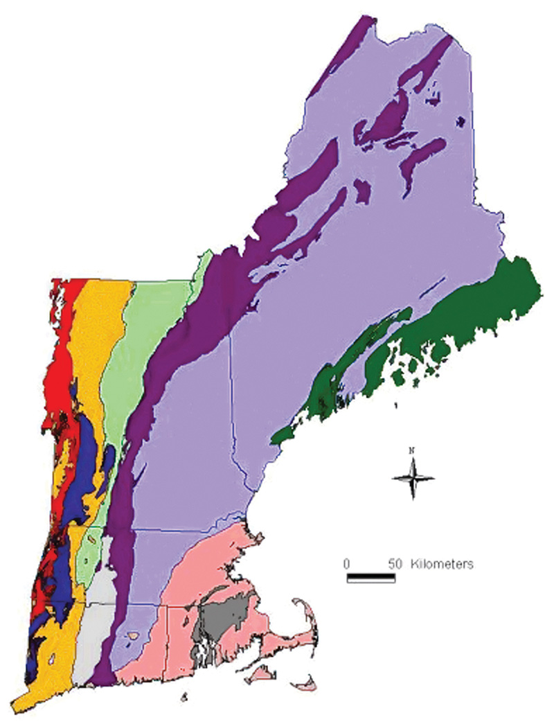
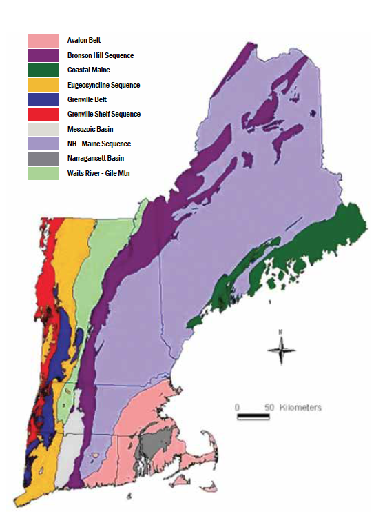
Geologic Provinces of New England. Image Credit: United States Geological Survey.
For such a small area, New England, Connecticut, and the Connecticut River Valley have an amazing diversity of geology. Going back to the earliest days of habitation, geology has driven settlement, transportation, construction, industry, and even art.
A long period of geologic activity would be needed to put together all the parts we see along roadcuts and in quarries and our backyards. In the 1960s, geologists recognized the theory that plate tectonics is the driver of all the volcanic and mountain building events that shape the Earth’s continents, through a series of continuous compression (collision) and extension (stretching and separation). They distinguish the various geologic areas as four different “terranes:” Proto North America, Iapetus (YAP-eh-toes), Avalonia, and Newark.
One Billion Years Ago: Proto North America
The oldest parts of New England are tiny slivers of Proto North America located on the then eastern edge of the continent. Some of these rocks have been dated to a billion years! Here is where New England begins, with pieces of the Grenville mountain building event. The rest of New England didn’t exist. This was the spot that the forthcoming pieces would glom onto in order to create what we know today. It was where the ancient waters of the Iapetus Ocean lapped the shore, depositing marine sediments.
450 Million Years Ago: Iapetus
For hundreds of millions of years, sediments eroded from the mountains to the west while deposits of ancient marine animals made of calcium carbonate accumulated offshore. Off to the east, the tectonic plates began to close ranks, and a volcanic arc similar to Japan formed at the depths of the ocean floor. As the motion of the plates compressed against Proto North America, the ocean slowly began to disappear, and the coastal sediments were thrust upward and folded like a huge rumpled rug. Metamorphism changed them to quartzites and marbles. These calcium-rich rocks support a different suite of plants and animals not found elsewhere.
The volcanic rocks from the island arc created a series of “domes,” known as the Bronson Hill complex, which stretches from Connecticut through Massachusetts and Vermont mostly along the Connecticut River corridor. These rocks are part of the Taconic mountain building event and consist mostly of metamorphic gneisses and schists. They make up the bulk of New England all the way to Canada.
(Gneiss is pronounced “NICE.” Gneisses are high grade metamorphic rocks that form under such high heat and pressure that they are on the verge of remelting into magma. They are easily folded deep within the Earth like toothpaste. Today, erosion and uplift have revealed spectacular folds seen along many roadcuts through the Connecticut Valley. Some gneiss, like the Glastonbury, is nicer than other gneiss!)
375 Million Years Ago: Avalonia
Mother Nature wasn’t done with us yet. New England was still incomplete. Rhode Island and eastern Massachusetts were still pretty much nonexistent. A group of small subcontinents referred to as Avalonia were caught up in more westward motion of compression and joined the edge of the newly expanded continent to form the eastern and southeastern corner of Connecticut and Rhode Island, finally closing the Iapetus Ocean. This was the Acadian mountain building event. The rocks range from granite to gneiss with lots of the pink feldspar mineral that makes them quite distinctive, especially as the base of the Statue of Liberty from Leete’s Island in Branford.
300 Million Years Ago
While New England was fully assembled, there was one last mountain building event—the Alleghenian—that renewed metamorphism in the south as the continents made one last push to become one.
250 Million Years Ago: Newark
While all the pieces of New England were now assembled, there were still millions of years more of geologic activity to come. By 250 million years ago, all the continents of the Earth had come together in a series of collisions to form one supercontinent called Pangea, meaning “all lands.” They hung out together for 50 million years through the evolution of dinosaurs, giving us our own “Jurassic Park.”
Pangea, with New England in the middle of the huge continent, was located much farther south, near the equator where the climate was warmer than it is today. Eventually, however, Pangea pulled apart to form, over millions of years of more compression and extension, the continents we know today.
While Pangea was literally coming apart at the seams, some of those seams called rifts were more successful at breaking free than others. One, to our east, became the Atlantic Ocean. Another, right through the middle of New England, was not completed, but while it was trying to rip itself free of Pangea, it sent hot, molten rock called magma into the rift. Some oozed out onto the surface forming lava flows. There were three periods of lava, some bigger than others. When the lava cooled, it formed basalt, what we in Connecticut call “traprock,” from the Swedish word for “step,” because it fractures in steplike forms.
Between the lava flows, there were long periods of quiescence that allowed the buildup of sediments in the Central Valley that filled the Hartford Basin in Connecticut and the Deerfield Basin in Massachusetts. Huge amounts of sediments eroded off the mountains to the east and west and formed four thick sedimentary deposits between the igneous basalts, like the layers of a cake. The sediments contained so much feldspar that they weathered over time into shades of mostly red and brown, giving them the collective name “redbeds,” but, geologically, they are arkose (a sandstone containing much feldspar). There were perhaps many more layers than there are today. If there were, they have long since eroded away.
As the Central Valley was being filled, the rifting created faults that bordered both the east and the west of the valley. The Eastern Border fault became dominate, dropping the valley about 15 degrees, like a trapdoor slightly ajar. As more erosion took place, the softer sedimentary rocks eroded faster, allowing the traprock to rise above as a line of ridges down the valley. These are the “hanging hills” that run north and south from Massachusetts to New Haven. Incomplete rifts like ours can be found all along the East Coast of North America.
While all this was going on, the stretching of Pangea created weak spots and fault zones where the magma became so hot and was under such pressure that it liquified and sought any space it could find. If there was enough space when it cooled, large crystals formed creating a rock called pegmatite that often contains valuable and gem-quality minerals. In the millions of years following the breakup of Pangea, minor faulting continues, as is well known in East Haddam, Connecticut, where small earthquakes—locally called the Moodus Noises—have frightened, confused, and bemused residents since the earliest days of settlement.
2 Million Years Ago: Glaciation
Finally, about two million years ago, the Earth cooled enough to freeze into massive continental ice sheets. There is evidence of four periods of glaciation on North America but only for two in New England. The last period of ice was the Wisconsinan that began about 80,000 years ago and ended in Connecticut about 15,000 years ago and all of New England around 9,000 years ago. The ice built up to a thickness of at least a mile, pressing down the land under its weight and scraping off every living thing, as well as tons more of all the rock formations in New England. It scoured rocks with deep grooves, dumped sediments from the ice as it moved back and forth, created huge lakes, left giant boulder “erratics,” sculpting the landscape. Glacial Lake Hitchcock stretched from its morainal dam at Rocky Hill, Connecticut, northward as far as Canada.
The Connecticut River
As the glacier receded, the land began to rebound from the weight of the ice. Melt water coalesced into streams and rivers and started downcutting through the various glacial deposits. One of those became the Connecticut River that mostly occupies the location of the once wide and deep Glacial Lake Hitchcock. Folks often believe that the river’s original course took it through the geologic Central Valley to New Haven, but the “Great River” never went to New Haven. South of the big bend between Middletown and Portland, a fault directs the flow to Old Saybrook where it cuts through bedrock rather than fertile glacial lake deposits. The shape and size of the watershed are also determined by the surrounding geology. Over time, plants and animals returned, all influenced by the geologic events of the past billion years.
When humans settled here, they took advantage of all of these incredible resources. The rich soils drew them to the valley to farm. They used every type of rock for building material, as well as sand and gravel from glacial deposits. The sandstone known as “brownstone” housed the rich in mansions and the working class in rowhouses in New York City and elsewhere. Wonderful mineral specimens were sought by collectors, including J. P. Morgan. Feldspar was sent to England in the colonial period for ceramics, and, here, it was quarried right into the 1990s for the porcelain industry. Mica was used for isinglass windows and insulation for radios in World War II. Gem material went to Tiffany’s in New York. Valley geology helped make the area the industrial incubator that it was famous for.
All along the Connecticut River from its mouth northward, folks have utilized the vast geology of the valley either locally for individual use or nationally for economic gain, adding greatly to our country’s agriculture, architecture, industry, and wealth.
Alison C. Guinness is a resident of East Haddam, CT, where she researches the local earthquake phenomenon called the Moodus Noises. She is an historian and naturalist with interest in Portland brownstone and other quarrying in the Connecticut River Valley. She has curated exhibits at the Connecticut River Museum on brownstone, Connecticut River fish and wildlife, and boat building. She is currently studying Connecticut’s Cultural Stone Landscapes.